Geolocate

Holt topographic map

Click on the map to display elevation.

About this map

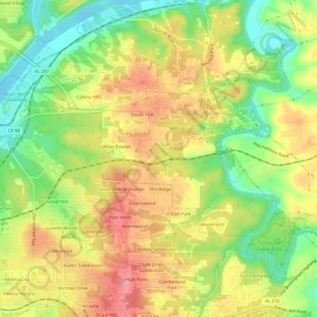
Name: Holt topographic map, elevation, terrain.

Location: Holt, Elm Ridge, Tuscaloosa County, Alabama, United States (33.20111 -87.50383 33.25076 -87.46157)

Average elevation: 289 ft

Minimum elevation: 121 ft

Maximum elevation: 443 ft

Tuscaloosa County trails, hiking, mountain biking, running and outdoor activities

Gear up for your next adventure:

🔭Stargazing Telescopes - Perfect for camping in low-light pollution areas shown on maps
🦟Ultrasonic Repellers - Create a bug-free zone at your camp or rest stop
☀️Outdoor Sunscreen - High protection sunscreen for outdoor activities
🌄Hiking Binoculars - Compact binoculars for scenic views and trail spotting
🧭Pro Hiking Compasses - High-accuracy liquid-filled compasses for topographic orientation

As an Amazon Associate, this site earns from qualifying purchases at no extra cost to you.