
Mawsynram topographic map
Click on the map to display elevation.
About this map
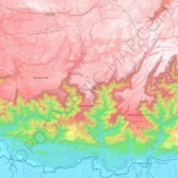
Name: Mawsynram topographic map, elevation, terrain.
Location: Mawsynram, East Khasi Hills District, Meghalaya, India (25.12272 91.35326 25.55464 91.75198)
Average elevation: 3,514 ft
Minimum elevation: 20 ft
Maximum elevation: 6,329 ft
Other topographic maps
Click on a map to view its topography, its elevation and its terrain.
Cherrapunji (Sohra)
India > Meghalaya > Shella Bholaganj > Cherrapunji (Sohra)
It has an average elevation of 1,430 metres (4,690 ft) and sits on a plateau in the southern part of the Khasi Hills, facing the plains of Bangladesh. The plateau rises 660 meters above the surrounding valleys.
Average elevation: 4,094 ft