
Île Paton topographic map
Interactive map
Click on the map to display elevation.
About this map
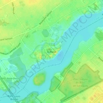
Name: Île Paton topographic map, elevation, terrain.
Location: Île Paton, Laval, Quebec, Canada (45.52062 -73.75354 45.52564 -73.74623)
Average elevation: 82 ft
Minimum elevation: 49 ft
Maximum elevation: 121 ft
Other topographic maps
Click on a map to view its topography, its elevation and its terrain.
Parc Paul-Marcel-Maheu
Parc Paul-Marcel-Maheu, Laval-des-Rapides, Laval, Laval (ville), Laval, Quebec, Canada
Average elevation: 95 ft