
Make a donation
Gear up for your next adventure:
As an Amazon Associate, this site earns from qualifying purchases at no extra cost to you.
Zugersee topographic map
Click on the map to display elevation.
Make a donation
Gear up for your next adventure:
As an Amazon Associate, this site earns from qualifying purchases at no extra cost to you.
Zugersee
Der Zugersee liegt in der Zentralschweiz auf einer Höhe von 413 m ü. M., hat eine Fläche von 38,41 km² und eine maximale Tiefe von 198 m. Mit seiner maximalen Länge von 13,7 km und seiner maximalen Breite von 4,6 km ist er der zehntgrösste See der Schweiz. An seiner engsten Stelle zwischen Chiemen und Lothenbach sind die Ufer ungefähr 1000 m voneinander entfernt. Der Zugersee hat zusammen mit der Seefläche ein Einzugsgebiet von 246 km².
Make a donation
Gear up for your next adventure:
As an Amazon Associate, this site earns from qualifying purchases at no extra cost to you.
About this map
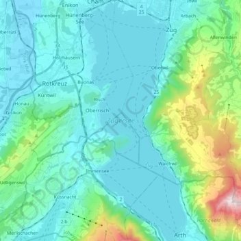
Name: Zugersee topographic map, elevation, terrain.
Location: Zugersee, Meierskappel, Küssnacht, Luzern, 6344, Schweiz (47.06146 8.45288 47.18286 8.52817)
Average elevation: 1,919 ft
Minimum elevation: 1,299 ft
Maximum elevation: 5,098 ft
Make a donation
Gear up for your next adventure:
As an Amazon Associate, this site earns from qualifying purchases at no extra cost to you.