
Mount Seymour topographic map
Interactive map
Click on the map to display elevation.
About this map
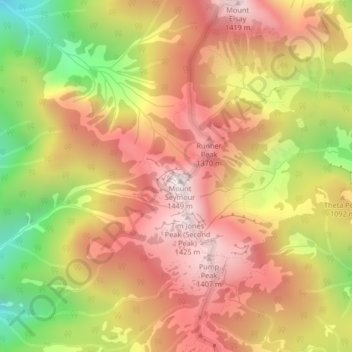
Name: Mount Seymour topographic map, elevation, terrain.
Average elevation: 3,369 ft
Minimum elevation: 1,519 ft
Maximum elevation: 4,708 ft
Other topographic maps
Click on a map to view its topography, its elevation and its terrain.
Lynn Canyon Park
Canada > British Columbia > District of North Vancouver
Lynn Canyon Park, Lynn Valley, District of North Vancouver, Metro Vancouver, British Columbia, V7J, Canada
Average elevation: 604 ft
Grouse Mountain
Canada > British Columbia > District of North Vancouver
Grouse Mountain, District of North Vancouver, Metro Vancouver Regional District, British Columbia, V7R 4L9, Canada
Average elevation: 3,176 ft