Geolocate

Liberty topographic map

Click on the map to display elevation.

About this map

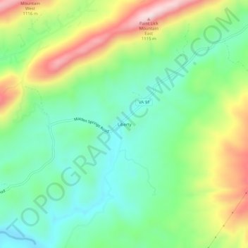
Name: Liberty topographic map, elevation, terrain.

Location: Liberty, Tazewell County, Virginia, United States (37.03678 -81.67400 37.07678 -81.63400)

Average elevation: 2,730 ft

Minimum elevation: 2,254 ft

Maximum elevation: 3,583 ft

Other topographic maps

Click on a map to view its topography, its elevation and its terrain.

Cedar Bluff

United States > Virginia > Tazewell County

Average elevation: 2,208 ft

Abbs Valley

United States > Virginia > Tazewell County > Abbs Valley

Average elevation: 2,818 ft

Gratton

United States > Virginia > Tazewell County > Gratton

Average elevation: 3,146 ft

Abbs Valley

United States > Virginia > Tazewell County > Abbs Valley

Average elevation: 2,818 ft

Bluefield

United States > Virginia > Tazewell County

Average elevation: 2,785 ft

Cedar Bluff

United States > Virginia > Tazewell County

Average elevation: 2,208 ft

Gear up for your next adventure:

🧭Outdoor Navigation Book - Learn advanced navigation skills
🚁Photography Drones - Capture stunning aerial views of landforms and topography
🧺Microfiber Travel Towels - Compact and fast-drying towels for trail use
📚Navigation Handbooks - Master the art of reading topographic maps and using a compass
🩹Survival Bandages - High‑quality bandages for emergencies

As an Amazon Associate, this site earns from qualifying purchases at no extra cost to you.