Geolocate

Alciston topographic map

Click on the map to display elevation.

About this map

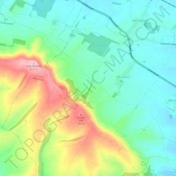
Name: Alciston topographic map, elevation, terrain.

Location: Alciston, Wealden, East Sussex, England, United Kingdom (50.81293 0.09791 50.84429 0.15584)

Average elevation: 269 ft

Minimum elevation: 46 ft

Maximum elevation: 712 ft

Gear up for your next adventure:

🌡️Handheld Weather Meters - Measure wind, temp, and pressure for safe mountain travel
🌎3D Topographic Globes - Raised relief globes for a tactile understanding of geography
🌐World Map Poster - Decorative world maps with topographic info
🪶Multi‑Purpose Knife - Useful blade for camp and trail
🏥Hiking First Aid Kits - Comprehensive medical kits for remote trail injuries

As an Amazon Associate, this site earns from qualifying purchases at no extra cost to you.