
Harmony topographic map
Click on the map to display elevation.
About this map
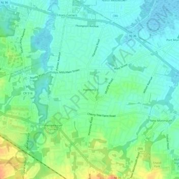
Name: Harmony topographic map, elevation, terrain.
Average elevation: 39 ft
Minimum elevation: -7 ft
Maximum elevation: 118 ft
Monmouth County trails, hiking, mountain biking, running and outdoor activities
Other topographic maps
Click on a map to view its topography, its elevation and its terrain.
North Middletown
United States > New Jersey > Monmouth County > Middletown Township > North Middletown
Average elevation: 10 ft
Navesink
United States > New Jersey > Monmouth County > Middletown Township > Navesink
Average elevation: 89 ft
Leonardo
United States > New Jersey > Monmouth County > Middletown Township > Leonardo
Average elevation: 20 ft