
Make a donation
Gear up for your next adventure:
As an Amazon Associate, this site earns from qualifying purchases at no extra cost to you.
Höllentalklamm topographic map
Click on the map to display elevation.
Make a donation
Gear up for your next adventure:
As an Amazon Associate, this site earns from qualifying purchases at no extra cost to you.
About this map
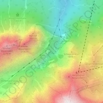
Name: Höllentalklamm topographic map, elevation, terrain.
Average elevation: 5,125 ft
Minimum elevation: 2,838 ft
Maximum elevation: 8,012 ft
Make a donation
Gear up for your next adventure:
As an Amazon Associate, this site earns from qualifying purchases at no extra cost to you.
Other topographic maps
Click on a map to view its topography, its elevation and its terrain.
Eibsee
Deutschland > Bayern > Landkreis Garmisch-Partenkirchen > Grainau
Im Nordosten ist der 4,8 ha große und 26 Meter tiefe Untersee durch eine 50 Meter breite und nur 0,5 Meter tiefe Engstelle vom Hauptteil des Sees, dem Weitsee mit seinen 172 ha, fast völlig abgetrennt. Über eine kleine Brücke an dieser Engstelle führt ein Wanderweg entlang des Eibsee-Nordufers. Die…
Average elevation: 3,658 ft
Zugspitze
Deutschland > Bayern > Landkreis Garmisch-Partenkirchen > Grainau
Die Zugspitze ist mit einer Höhe von 2962 Metern (Ostgipfel) der höchste Berg des Zugspitzmassivs. Dieser Wert nach dem Amsterdamer Pegel wird als offizielle Höhe vom Landesamt für Digitalisierung, Breitband und Vermessung genannt. Nach dem in Österreich verwendeten 27 cm tiefer liegenden Triester Pegel…
Average elevation: 7,546 ft
Make a donation
Gear up for your next adventure:
As an Amazon Associate, this site earns from qualifying purchases at no extra cost to you.