
Make a donation
Gear up for your next adventure:
As an Amazon Associate, this site earns from qualifying purchases at no extra cost to you.
Tensbüttel-Röst topographic map
Click on the map to display elevation.
Make a donation
Gear up for your next adventure:
As an Amazon Associate, this site earns from qualifying purchases at no extra cost to you.
Tensbüttel-Röst
Die Namensgebung für Tensbüttel wird auf die Zeit zwischen dem 9. und 11. Jahrhundert datiert. Tins bedeutet vermutlich andere Seite und Büttel ist mit Ansiedlung auf höherer Stelle zu deuten.
Make a donation
Gear up for your next adventure:
As an Amazon Associate, this site earns from qualifying purchases at no extra cost to you.
About this map
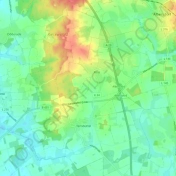
Name: Tensbüttel-Röst topographic map, elevation, terrain.
Average elevation: 72 ft
Minimum elevation: 3 ft
Maximum elevation: 220 ft
Make a donation
Gear up for your next adventure:
As an Amazon Associate, this site earns from qualifying purchases at no extra cost to you.
Other topographic maps
Click on a map to view its topography, its elevation and its terrain.
Make a donation
Gear up for your next adventure:
As an Amazon Associate, this site earns from qualifying purchases at no extra cost to you.
WKK Ententeich
Deutschland > Schleswig-Holstein > Dithmarschen > Heide > Hochfeld
Average elevation: 26 ft
Make a donation
Gear up for your next adventure:
As an Amazon Associate, this site earns from qualifying purchases at no extra cost to you.
Make a donation
Gear up for your next adventure:
As an Amazon Associate, this site earns from qualifying purchases at no extra cost to you.
Zippelkoog
Deutschland > Schleswig-Holstein > Dithmarschen > Helse > Zippelkoog
Average elevation: 3 ft
Make a donation
Gear up for your next adventure:
As an Amazon Associate, this site earns from qualifying purchases at no extra cost to you.
Poppenwurth
Deutschland > Schleswig-Holstein > Dithmarschen > Oesterwurth > Poppenwurth
Average elevation: 7 ft
Make a donation
Gear up for your next adventure:
As an Amazon Associate, this site earns from qualifying purchases at no extra cost to you.
Oldörpen
Deutschland > Schleswig-Holstein > Dithmarschen > Tensbüttel-Röst > Tensbüttel > Oldörpen
Average elevation: 56 ft