Geolocate

Nocera Inferiore topographic map

Click on the map to display elevation.

👉 Easily get elevation data in JSON, GeoTIFF and KML formats using Elevation API
Thank you for supporting this site ❤️
Make a donation

About this map

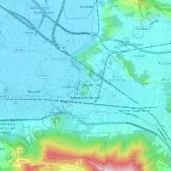
Name: Nocera Inferiore topographic map, elevation, terrain.

Location: Nocera Inferiore, Salerno, Campania, 84014, Italy (40.71507 14.61048 40.79012 14.65959)

Average elevation: 509 ft

Minimum elevation: 52 ft

Maximum elevation: 3,458 ft

Other topographic maps

Click on a map to view its topography, its elevation and its terrain.

Montepertuso

Italy > Campania > Salerno > Arienzo

Average elevation: 1,493 ft

Valico di Chiunzi

Italy > Campania > Salerno

Average elevation: 1,680 ft

Persano

Italy > Campania > Salerno > Serre

Average elevation: 82 ft

M.Licosa

Italy > Campania > Salerno

Average elevation: 374 ft

Il Gallo Lungo

Italy > Campania > Salerno > Positano

Average elevation: 0 ft

Sicilì

Italy > Campania > Salerno

Average elevation: 748 ft

Gear up for your next adventure:

🧦Merino Wool Socks - Moisture-wicking, blister-preventing socks for long treks
📷Action Cameras - Rugged cameras to document your journeys across rugged terrain
🪵Folding Camp Saw - Compact saw for wood and campsite work
🪑Ultralight Camp Chairs - Portable seating for resting after a long day of mapping
🦶Hiking Gaiters - Keep debris and water out of your boots

As an Amazon Associate, this site earns from qualifying purchases at no extra cost to you.