
Make a donation
Gear up for your next adventure:
As an Amazon Associate, this site earns from qualifying purchases at no extra cost to you.
Kautenbach topographic map
Click on the map to display elevation.
Make a donation
Gear up for your next adventure:
As an Amazon Associate, this site earns from qualifying purchases at no extra cost to you.
Kautenbach
Kautenbach wird erstmals 1334 erwähnt. Der einige Jahrhunderte betriebene frühere Bergbau erreichte im 18. Jahrhundert seinen Höhepunkt, vor allem Blei und Kupfer wurden abgebaut.
Make a donation
Gear up for your next adventure:
As an Amazon Associate, this site earns from qualifying purchases at no extra cost to you.
About this map
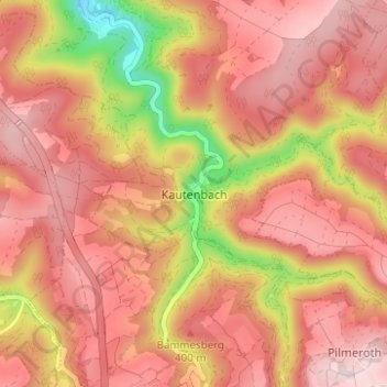
Name: Kautenbach topographic map, elevation, terrain.
Average elevation: 1,132 ft
Minimum elevation: 417 ft
Maximum elevation: 1,496 ft
Make a donation
Gear up for your next adventure:
As an Amazon Associate, this site earns from qualifying purchases at no extra cost to you.
Other topographic maps
Click on a map to view its topography, its elevation and its terrain.
Kautenbach
Deutschland > Rheinland-Pfalz > Landkreis Bernkastel-Wittlich > Traben-Trarbach
Average elevation: 1,191 ft
Grevenburg
Deutschland > Rheinland-Pfalz > Landkreis Bernkastel-Wittlich > Traben-Trarbach
Die Grevenburg ist die Ruine einer Höhenburg über dem Stadtteil Trarbach (Traben-Trarbach / Mosel) im Landkreis Bernkastel-Wittlich in Rheinland-Pfalz und war die ehemalige Residenz der Grafen von Sponheim.
Average elevation: 745 ft