Geolocate

Verdi topographic map

Click on the map to display elevation.

About this map

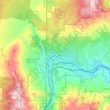
Name: Verdi topographic map, elevation, terrain.

Location: Verdi, Washoe County, Nevada, 89515, United States (39.48283 -120.00250 39.53457 -119.92778)

Average elevation: 5,312 ft

Minimum elevation: 4,741 ft

Maximum elevation: 6,765 ft

Washoe County trails, hiking, mountain biking, running and outdoor activities

Other topographic maps

Click on a map to view its topography, its elevation and its terrain.

Verdi

United States > Nevada > Washoe County

Average elevation: 5,062 ft

Mount Rose

United States > Nevada > Washoe County

Average elevation: 9,577 ft

Gerlach

United States > Nevada > Washoe County

According to the United States Census Bureau, the Gerlach CDP has a total area of 3.1 square miles (8.0 km2), all land. Its elevation is 3,944 ft (1,202 m). Gerlach is approximately 100 miles (160 km) north of Reno, Nevada.

Average elevation: 3,963 ft

Red Rock

United States > Nevada > Washoe County

Average elevation: 4,803 ft

Palomino Valley

United States > Nevada > Washoe County

Average elevation: 4,370 ft

State Line Peak

United States > Nevada > Washoe County

Average elevation: 6,952 ft

Pyramid

United States > Nevada > Washoe County

Average elevation: 4,173 ft

Lemmon Valley

United States > Nevada > Washoe County

Average elevation: 5,049 ft

Tohakum Peak

United States > Nevada > Washoe County

Average elevation: 6,883 ft

Golden Valley Park

United States > Nevada > Washoe County > Reno

Average elevation: 5,171 ft

Red Rock

United States > Nevada > Washoe County

Average elevation: 4,803 ft

Lemmon Valley

United States > Nevada > Washoe County

Average elevation: 5,049 ft

Highland Reservoir

United States > Nevada > Washoe County > Reno

Average elevation: 4,665 ft

Mount Rose

United States > Nevada > Washoe County

Average elevation: 9,577 ft

Sand Pass

United States > Nevada > Washoe County

Average elevation: 4,117 ft

Mount Rose

United States > Nevada > Washoe County

Average elevation: 9,577 ft

Verdi

United States > Nevada > Washoe County

Average elevation: 5,062 ft

Cold Springs

United States > Nevada > Washoe County

Average elevation: 5,161 ft

Incline Village

United States > Nevada > Washoe County

Average elevation: 7,136 ft

Gear up for your next adventure:

👓Polarized Sunglasses - Outdoor sunglasses for glare reduction
🛌Ultralight Sleeping Bags - Compact down bags for cold nights in the wilderness
🧤Tactile Hiking Gloves - Keep hands warm while operating GPS and smartphone screens
🗺️NatGeo Topo Maps - High-quality waterproof printed topographic maps of US Parks
🧭Orienteering Set - Complete compass and map reading kit

As an Amazon Associate, this site earns from qualifying purchases at no extra cost to you.