
Thank you for supporting this site ❤️
Make a donation
Make a donation
Gear up for your next adventure:
As an Amazon Associate, this site earns from qualifying purchases at no extra cost to you.
Tsoundzou 1 topographic map
Click on the map to display elevation.
Thank you for supporting this site ❤️
Make a donation
Make a donation
Gear up for your next adventure:
As an Amazon Associate, this site earns from qualifying purchases at no extra cost to you.
About this map
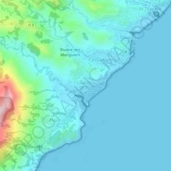
Name: Tsoundzou 1 topographic map, elevation, terrain.
Location: Tsoundzou 1, Mamoudzou, Mayotte, 97605, France (-12.82724 45.18515 -12.78724 45.22515)
Average elevation: 171 ft
Minimum elevation: -3 ft
Maximum elevation: 1,201 ft
Thank you for supporting this site ❤️
Make a donation
Make a donation
Gear up for your next adventure:
As an Amazon Associate, this site earns from qualifying purchases at no extra cost to you.