
Buôn Hồ District topographic map
Interactive map
Click on the map to display elevation.
About this map
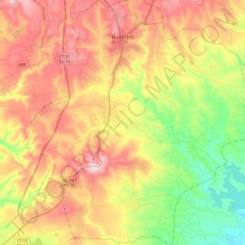
Name: Buôn Hồ District topographic map, elevation, terrain.
Location: Buôn Hồ District, Đắk Lắk province, Vietnam (12.75249 108.18701 12.94799 108.37190)
Average elevation: 2,034 ft
Minimum elevation: 1,493 ft
Maximum elevation: 2,562 ft
Other topographic maps
Click on a map to view its topography, its elevation and its terrain.
Cư M'gar District
Cư M'gar District, Đắk Lắk Province, Vietnam
Average elevation: 1,542 ft
Buôn Ma Thuột
Buôn Ma Thuột, Đắk Lắk Province, Vietnam
Average elevation: 1,450 ft
Ea H'leo District
Ea H'leo District, Đăk Lăk Province, Vietnam
Average elevation: 1,578 ft
Buôn Ma Thuột
Vietnam > Đắk Lắk province > Buon Ma Thuot > Buôn Ma Thuột
Buôn Ma Thuột, Buon Ma Thuot, Đắk Lắk province, 63000, Vietnam
Average elevation: 1,434 ft