
Tiniroto topographic map
Interactive map
Click on the map to display elevation.
About this map
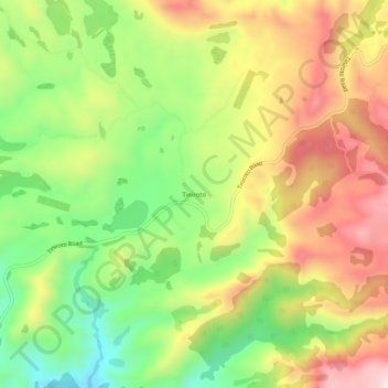
Name: Tiniroto topographic map, elevation, terrain.
Location: Tiniroto, Gisborne, New Zealand (-38.79347 177.54704 -38.75347 177.58704)
Average elevation: 1,076 ft
Minimum elevation: 417 ft
Maximum elevation: 1,785 ft
Other topographic maps
Click on a map to view its topography, its elevation and its terrain.
Gisborne
New Zealand > Gisborne > Gisborne District
Gisborne, Gisborne District, Gisborne, 4010, New Zealand
Average elevation: 230 ft
Gisborne District
Gisborne District, Gisborne, New Zealand
Average elevation: 748 ft
Titirangi
New Zealand > Gisborne > Gisborne
Titirangi, Gisborne, 4020, New Zealand
Average elevation: 62 ft
Whangaparāoa River
New Zealand > Gisborne > Ōpōtiki District
Whangaparāoa River, Ōpōtiki District, Gisborne, New Zealand
Average elevation: 627 ft
Makauri
New Zealand > Gisborne > Gisborne
Makauri, Gisborne, 4071, New Zealand
Average elevation: 33 ft
Te Puia Springs
Te Puia Springs, Gisborne, 4079, New Zealand
Average elevation: 778 ft