
Lac Louisa topographic map
Interactive map
Click on the map to display elevation.
About this map
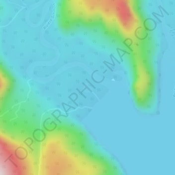
Name: Lac Louisa topographic map, elevation, terrain.
Average elevation: 659 ft
Minimum elevation: 364 ft
Maximum elevation: 1,936 ft
Other topographic maps
Click on a map to view its topography, its elevation and its terrain.
Lac Serpent
Canada > Québec > Sept-Rivières > Lac-Walker
Lac Serpent, Lac-Walker, Sept-Rivières, Côte-Nord, Québec, Canada
Average elevation: 1,562 ft
Lac Roger
Canada > Québec > Sept-Rivières > Lac-Walker
Lac Roger, Lac-Walker, Sept-Rivières, Côte-Nord, Québec, Canada
Average elevation: 807 ft
Lac Veillette
Canada > Québec > Sept-Rivières > Lac-Walker
Lac Veillette, Lac-Walker, Sept-Rivières, Côte-Nord, Québec, Canada
Average elevation: 1,037 ft
Lac-Walker
Canada > Québec > Sept-Rivières > Lac-Walker
Lac-Walker, Sept-Rivières, Côte-Nord, Québec, Canada
Average elevation: 1,424 ft
Lac Arthur
Canada > Québec > Sept-Rivières > Lac-Walker
Lac Arthur, Lac-Walker, Sept-Rivières, Côte-Nord, Québec, Canada
Average elevation: 1,686 ft
Lac Francis
Canada > Québec > Sept-Rivières > Lac-Walker
Lac Francis, Lac-Walker, Sept-Rivières, Côte-Nord, Québec, Canada
Average elevation: 2,169 ft
Lac Perle
Canada > Québec > Sept-Rivières > Lac-Walker
Lac Perle, Lac-Walker, Sept-Rivières, Côte-Nord, Québec, Canada
Average elevation: 1,024 ft
Lac Louisa
Canada > Québec > Sept-Rivières > Lac-Walker
Lac Louisa, Lac-Walker, Sept-Rivières, Côte-Nord, Québec, Canada
Average elevation: 659 ft