Geolocate

Lac-Walker topographic map

Interactive map

Click on the map to display elevation.

About this map

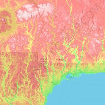
Name: Lac-Walker topographic map, elevation, terrain.

Location: Lac-Walker, Sept-Rivières, Côte-Nord, Québec, Canada (49.58942 -67.92476 51.85095 -66.09783)

Average elevation: 1,424 ft

Minimum elevation: 0 ft

Maximum elevation: 3,596 ft

Other topographic maps

Click on a map to view its topography, its elevation and its terrain.

Lac Serpent

Canada > Québec > Sept-Rivières > Lac-Walker

Lac Serpent, Lac-Walker, Sept-Rivières, Côte-Nord, Québec, Canada

Average elevation: 1,562 ft

Lac Roger

Canada > Québec > Sept-Rivières > Lac-Walker

Lac Roger, Lac-Walker, Sept-Rivières, Côte-Nord, Québec, Canada

Average elevation: 807 ft

Lac Veillette

Canada > Québec > Sept-Rivières > Lac-Walker

Lac Veillette, Lac-Walker, Sept-Rivières, Côte-Nord, Québec, Canada

Average elevation: 1,037 ft

Lac Arthur

Canada > Québec > Sept-Rivières > Lac-Walker

Lac Arthur, Lac-Walker, Sept-Rivières, Côte-Nord, Québec, Canada

Average elevation: 1,686 ft

Lac Louisa

Canada > Québec > Sept-Rivières > Lac-Walker

Lac Louisa, Lac-Walker, Sept-Rivières, Côte-Nord, Québec, Canada

Average elevation: 659 ft

Lac Francis

Canada > Québec > Sept-Rivières > Lac-Walker

Lac Francis, Lac-Walker, Sept-Rivières, Côte-Nord, Québec, Canada

Average elevation: 2,169 ft

Lac Perle

Canada > Québec > Sept-Rivières > Lac-Walker

Lac Perle, Lac-Walker, Sept-Rivières, Côte-Nord, Québec, Canada

Average elevation: 1,024 ft

Lac Louisa

Canada > Québec > Sept-Rivières > Lac-Walker

Lac Louisa, Lac-Walker, Sept-Rivières, Côte-Nord, Québec, Canada

Average elevation: 659 ft