
Thank you for supporting this site ❤️
Make a donation
Make a donation
Gear up for your next adventure:
As an Amazon Associate, this site earns from qualifying purchases at no extra cost to you.
Ganyesa topographic map
Click on the map to display elevation.
Thank you for supporting this site ❤️
Make a donation
Make a donation
Gear up for your next adventure:
As an Amazon Associate, this site earns from qualifying purchases at no extra cost to you.
About this map
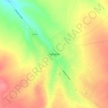
Name: Ganyesa topographic map, elevation, terrain.
Average elevation: 4,236 ft
Minimum elevation: 4,098 ft
Maximum elevation: 4,344 ft
Thank you for supporting this site ❤️
Make a donation
Make a donation
Gear up for your next adventure:
As an Amazon Associate, this site earns from qualifying purchases at no extra cost to you.
Other topographic maps
Click on a map to view its topography, its elevation and its terrain.
Kagisano-Molopo Local Municipality
South Africa > North West > Dr Ruth Segomotsi Mompati District Municipality > Kagisano-Molopo Local Municipality
Average elevation: 3,802 ft