Geolocate

Naul topographic map

Click on the map to display elevation.

About this map

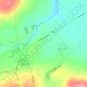
Name: Naul topographic map, elevation, terrain.

Location: Naul, Fingal, County Dublin, Leinster, Ireland (53.58081 -6.29192 53.59617 -6.26821)

Average elevation: 266 ft

Minimum elevation: 118 ft

Maximum elevation: 541 ft

Other topographic maps

Click on a map to view its topography, its elevation and its terrain.

Alder

Ireland > County Dublin > Goatstown

Average elevation: 187 ft

Cornelscourt

Ireland > County Dublin

Average elevation: 194 ft

Ballyogan

Ireland > County Dublin

Average elevation: 381 ft

14

Ireland > County Dublin > Blackrock

Average elevation: 157 ft

Goatstown

Ireland > County Dublin

Average elevation: 187 ft

Gear up for your next adventure:

🏕️Family Camping Gear - Essentials for group camping trips
🔥Fast-Boil Camping Stoves - Efficient cooking systems for quick trail meals
🔦LED Headlamp - Bright and durable LED headlamp for night navigation
🏫Relief Map Kits - Hands-on tools for teaching landforms and elevation
🏔️Mountain Trail Maps - High‑detail maps for popular peaks

As an Amazon Associate, this site earns from qualifying purchases at no extra cost to you.