Geolocate

Markesan topographic map

Click on the map to display elevation.

About this map

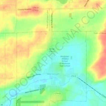
Name: Markesan topographic map, elevation, terrain.

Location: Markesan, Green Lake County, Wisconsin, United States (43.69721 -89.00593 43.73050 -88.97533)

Average elevation: 925 ft

Minimum elevation: 840 ft

Maximum elevation: 1,020 ft

Green Lake County trails, hiking, mountain biking, running and outdoor activities

Other topographic maps

Click on a map to view its topography, its elevation and its terrain.

Center House

United States > Wisconsin > Green Lake County

Average elevation: 951 ft

Fairburn

United States > Wisconsin > Green Lake County

Average elevation: 771 ft

Greenwyck

United States > Wisconsin > Green Lake County

Average elevation: 840 ft

Indian Hills

United States > Wisconsin > Green Lake County

Average elevation: 837 ft

Spring Grove

United States > Wisconsin > Green Lake County

Average elevation: 853 ft

Tuleta Hills

United States > Wisconsin > Green Lake County

Average elevation: 837 ft

Utley

United States > Wisconsin > Green Lake County

Average elevation: 955 ft

Dalton

United States > Wisconsin > Green Lake County

Average elevation: 846 ft

Gear up for your next adventure:

Solar GPS Watches - Advanced multisport watches with built-in topographic maps
🔭Compact Binoculars - HD vision for scouting terrain and identifying distant landmarks
🪶Survival Guide Book - Expert advice for emergency preparedness
🩳Quick‑Dry Hiking Shorts - Comfortable and quick‑dry shorts for summer hiking
🚗GPS Dash Cams - Record your scenic drives through mountain passes and canyons

As an Amazon Associate, this site earns from qualifying purchases at no extra cost to you.