
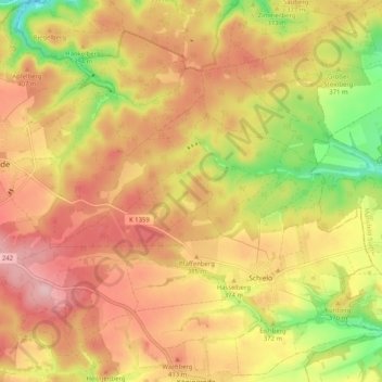
Schielo topographic map
Interactive map
Click on the map to display elevation.
About this map
Name: Schielo topographic map, elevation, terrain.
Average elevation: 1,220 ft
Minimum elevation: 856 ft
Maximum elevation: 1,483 ft
Alexisbad mit Hänichen und Klostermühle | Dankerode | Stadt Güntersberge mit Bärenrode und Friedrichshöhe | Harzgerode | Königerode | Mägdesprung | Neudorf | Schielo | Silberhütte | Siptenfelde | Straßberg mit Lindenberg
Other topographic maps
Click on a map to view its topography, its elevation and its terrain.
Siptenfelde
Deutschland > Sachsen-Anhalt > Landkreis Harz > Harzgerode
Siptenfelde, Harzgerode, Landkreis Harz, Sachsen-Anhalt, Deutschland
Average elevation: 1,417 ft
Dankerode
Deutschland > Sachsen-Anhalt > Landkreis Harz > Harzgerode
Dankerode, Harzgerode, Landkreis Harz, Sachsen-Anhalt, Deutschland
Average elevation: 1,299 ft
-berg
Deutschland > Sachsen-Anhalt > Landkreis Harz > Harzgerode
-berg, Güntersberge, Harzgerode, Landkreis Harz, Sachsen-Anhalt, Deutschland
Average elevation: 1,545 ft
Silberhütte
Deutschland > Sachsen-Anhalt > Landkreis Harz > Harzgerode
Silberhütte, Harzgerode, Landkreis Harz, Sachsen-Anhalt, Deutschland
Average elevation: 1,299 ft
Küchenholz
Deutschland > Sachsen-Anhalt > Landkreis Harz > Harzgerode
Küchenholz, Schielo, Harzgerode, Landkreis Harz, Sachsen-Anhalt, 06493, Deutschland
Average elevation: 1,243 ft
Alexisbad
Deutschland > Sachsen-Anhalt > Landkreis Harz > Harzgerode
Alexisbad, Harzgerode, Landkreis Harz, Sachsen-Anhalt, Deutschland
Average elevation: 1,257 ft