
-berg topographic map
Interactive map
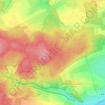
Click on the map to display elevation.
About this map
Name: -berg topographic map, elevation, terrain.
Average elevation: 1,545 ft
Minimum elevation: 1,319 ft
Maximum elevation: 1,699 ft
Other topographic maps
Click on a map to view its topography, its elevation and its terrain.
Straßberg
Deutschland > Sachsen-Anhalt > Landkreis Harz > Harzgerode
Alexisbad mit Hänichen und Klostermühle | Dankerode | Stadt Güntersberge mit Bärenrode und Friedrichshöhe | Harzgerode | Königerode | Mägdesprung | Neudorf | Schielo | Silberhütte | Siptenfelde | Straßberg mit Lindenberg
Average elevation: 1,398 ft
Güntersberge
Deutschland > Sachsen-Anhalt > Landkreis Harz > Harzgerode
Neben der eigentlichen Ortslage Güntersberge (651 Einwohner) gehören noch die Ansiedlungen Friedrichshöhe (41 Einwohner) und Bärenrode (21 Einwohner) zum Ortsteil. (Einwohner Stand 2019)
Average elevation: 1,532 ft
Siptenfelde
Deutschland > Sachsen-Anhalt > Landkreis Harz > Harzgerode
Alexisbad mit Hänichen und Klostermühle | Dankerode | Stadt Güntersberge mit Bärenrode und Friedrichshöhe | Harzgerode | Königerode | Mägdesprung | Neudorf | Schielo | Silberhütte | Siptenfelde | Straßberg mit Lindenberg
Average elevation: 1,417 ft
Dankerode
Deutschland > Sachsen-Anhalt > Landkreis Harz > Harzgerode
Dankerode liegt im Unterharz in einer Höhe von 420 m über Normalnull. Südlich des Ortes mündet das Marktal in das Wippertal. Dankerode ist von der Bundesstraße 242 über Königerode oder aus Richtung Neudorf zu erreichen. Auf dieser verkehrt die Regionalbuslinie 254 der Harzer Verkehrsbetriebe und…
Average elevation: 1,299 ft
Schielo
Deutschland > Sachsen-Anhalt > Landkreis Harz > Harzgerode
Alexisbad mit Hänichen und Klostermühle | Dankerode | Stadt Güntersberge mit Bärenrode und Friedrichshöhe | Harzgerode | Königerode | Mägdesprung | Neudorf | Schielo | Silberhütte | Siptenfelde | Straßberg mit Lindenberg
Average elevation: 1,220 ft