Geolocate

Madison Heights topographic map

Click on the map to display elevation.

About this map

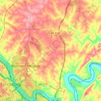
Name: Madison Heights topographic map, elevation, terrain.

Location: Madison Heights, Amherst County, Virginia, United States (37.39735 -79.15037 37.49531 -79.04586)

Average elevation: 722 ft

Minimum elevation: 449 ft

Maximum elevation: 935 ft

Amherst County trails, hiking, mountain biking, running and outdoor activities

Gear up for your next adventure:

🦶Carbon Trekking Poles - Reduce knee impact on steep descents with ultra-light poles
🛡️Insect Repellent - Protection against bugs during outdoor activities
🪶Paracord Bracelet - Survival bracelet with built‑in tools
🧴Hand Sanitizer - Keep hands clean while hiking
🩹Survival Bandages - High‑quality bandages for emergencies

As an Amazon Associate, this site earns from qualifying purchases at no extra cost to you.