
Make a donation
Gear up for your next adventure:
As an Amazon Associate, this site earns from qualifying purchases at no extra cost to you.
Les Gobelets topographic map
Click on the map to display elevation.
Make a donation
Gear up for your next adventure:
As an Amazon Associate, this site earns from qualifying purchases at no extra cost to you.
About this map
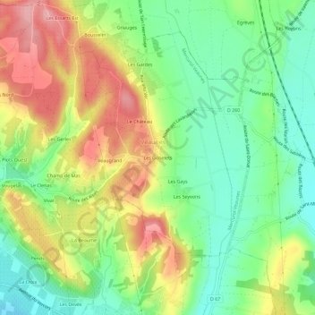
Name: Les Gobelets topographic map, elevation, terrain.
Average elevation: 679 ft
Minimum elevation: 482 ft
Maximum elevation: 938 ft
Make a donation
Gear up for your next adventure:
As an Amazon Associate, this site earns from qualifying purchases at no extra cost to you.
Other topographic maps
Click on a map to view its topography, its elevation and its terrain.
Mercurol
France > Auvergne-Rhône-Alpes > Drôme > Mercurol-Veaunes
Dictionnaire topographique du département de la Drôme.
Average elevation: 591 ft
Veaunes
France > Auvergne-Rhône-Alpes > Drôme > Mercurol-Veaunes
Dictionnaire topographique du département de la Drôme.
Average elevation: 663 ft