
Make a donation
Gear up for your next adventure:
As an Amazon Associate, this site earns from qualifying purchases at no extra cost to you.
Ottmaring topographic map
Click on the map to display elevation.
Make a donation
Gear up for your next adventure:
As an Amazon Associate, this site earns from qualifying purchases at no extra cost to you.
Ottmaring
„Eine halbe Stunde südöstlich von Friedberg liegt das freundliche, an einen sanften Hügel gelehnte Pfarrdorf Ottmaring. Das ganze Thal durchschlängelt das kleine Flüsschen, die Paar genannt. Auf der Höhe des Hügels liegt die, von Morgen gegen Abend ganz frei stehend und in mäßiger Entfernung vom Pfarrhaus und dessen Nebengebäuden eingeschlossen“
Make a donation
Gear up for your next adventure:
As an Amazon Associate, this site earns from qualifying purchases at no extra cost to you.
About this map
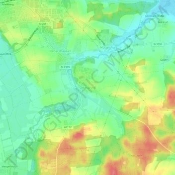
Name: Ottmaring topographic map, elevation, terrain.
Average elevation: 1,660 ft
Minimum elevation: 1,562 ft
Maximum elevation: 1,808 ft
Make a donation
Gear up for your next adventure:
As an Amazon Associate, this site earns from qualifying purchases at no extra cost to you.
Other topographic maps
Click on a map to view its topography, its elevation and its terrain.
Friedberger Baggersee
Deutschland > Bayern > Landkreis Aichach-Friedberg > Friedberg
Average elevation: 1,591 ft
86316
Deutschland > Bayern > Landkreis Aichach-Friedberg > Friedberg > Wiffertshausen
Average elevation: 1,627 ft