
Huaytará topographic map
Interactive map
Click on the map to display elevation.
About this map
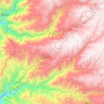
Name: Huaytará topographic map, elevation, terrain.
Location: Huaytará, Huancavelica, Perú (-13.81790 -75.55458 -13.51546 -75.18543)
Average elevation: 10,459 ft
Minimum elevation: 3,914 ft
Maximum elevation: 14,803 ft
Other topographic maps
Click on a map to view its topography, its elevation and its terrain.
San Pedro de Coris
Perú > Huancavelica > San Pedro de Coris
San Pedro de Coris, Provincia de Churcampa, Huancavelica, Perú
Average elevation: 11,555 ft
Provincia de Huancavelica
Perú > Huancavelica > Nuevo Occoro
Provincia de Huancavelica, Nuevo Occoro, Huancavelica, Perú
Average elevation: 15,135 ft