Geolocate

Cumbe topographic map

Click on the map to display elevation.

About this map

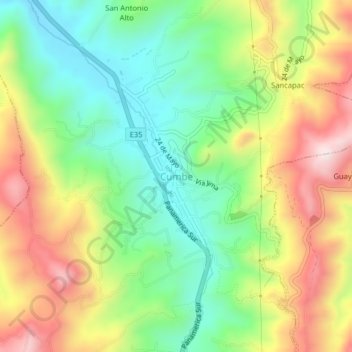
Name: Cumbe topographic map, elevation, terrain.

Location: Cumbe, Cuenca, Azuay, Ecuador (-3.10712 -79.03109 -3.06712 -78.99109)

Average elevation: 9,406 ft

Minimum elevation: 8,691 ft

Maximum elevation: 10,390 ft

Other topographic maps

Click on a map to view its topography, its elevation and its terrain.

Río Tomebamba

Ecuador > Azuay > Cuenca

Average elevation: 8,212 ft

San Sebastián

Ecuador > Azuay > Cuenca

Average elevation: 9,026 ft

Gear up for your next adventure:

🛠️Outdoor Gear Repair Kit - Essential tools to fix gear on the trail
👓Polarized Sunglasses - Outdoor sunglasses for glare reduction
🖼️Topo Map Wall Art - Decorative topographic prints of famous peaks and regions
🛶Inflatable Kayak - Portable kayak for rivers, lakes, and expeditions
🛏️Cold Weather Sleeping Bag - Warm sleeping bag for cold conditions

As an Amazon Associate, this site earns from qualifying purchases at no extra cost to you.