
Make a donation
Gear up for your next adventure:
As an Amazon Associate, this site earns from qualifying purchases at no extra cost to you.
Dahmi Kalan topographic map
Click on the map to display elevation.
Make a donation
Gear up for your next adventure:
As an Amazon Associate, this site earns from qualifying purchases at no extra cost to you.
About this map
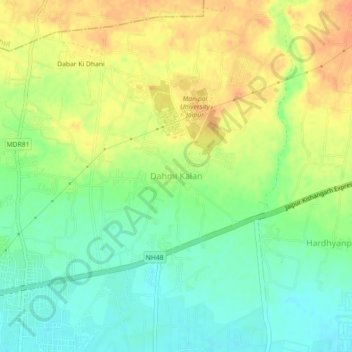
Name: Dahmi Kalan topographic map, elevation, terrain.
Location: Dahmi Kalan, Sanganer Tehsil, Jaipur, Rajasthan, 303007, India (26.81506 75.54309 26.85506 75.58309)
Average elevation: 1,214 ft
Minimum elevation: 1,152 ft
Maximum elevation: 1,280 ft
Make a donation
Gear up for your next adventure:
As an Amazon Associate, this site earns from qualifying purchases at no extra cost to you.
Other topographic maps
Click on a map to view its topography, its elevation and its terrain.
Haldighati Park
India > Rajasthan > Sanganer Tehsil > Jaipur Municipal Corporation
Average elevation: 1,220 ft
Ranvir shekhawat park
India > Rajasthan > Sanganer Tehsil > Jaipur Municipal Corporation
Average elevation: 1,355 ft
Haldighati Park
India > Rajasthan > Sanganer Tehsil > Jaipur Municipal Corporation
Average elevation: 1,220 ft