
Manicuare topographic map
Click on the map to display elevation.
About this map
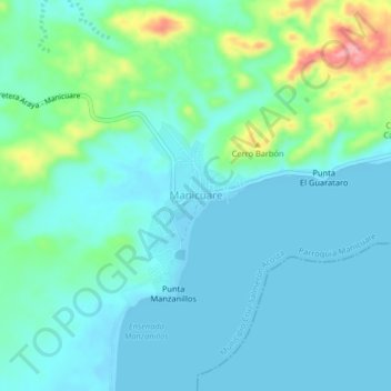
Name: Manicuare topographic map, elevation, terrain.
Average elevation: 75 ft
Minimum elevation: -3 ft
Maximum elevation: 381 ft
Other topographic maps
Click on a map to view its topography, its elevation and its terrain.
Península de Araya
Venezuela > Estado Sucre > Municipio Cruz Salmerón Acosta
Average elevation: 410 ft