
Make a donation
Gear up for your next adventure:
As an Amazon Associate, this site earns from qualifying purchases at no extra cost to you.
Parc Geisendorf topographic map
Click on the map to display elevation.
Make a donation
Gear up for your next adventure:
As an Amazon Associate, this site earns from qualifying purchases at no extra cost to you.
About this map
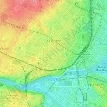
Name: Parc Geisendorf topographic map, elevation, terrain.
Location: Parc Geisendorf, Grottes et Saint-Gervais, Genève, Suisse (46.20860 6.12871 46.21079 6.13282)
Average elevation: 1,335 ft
Minimum elevation: 1,204 ft
Maximum elevation: 1,499 ft
Make a donation
Gear up for your next adventure:
As an Amazon Associate, this site earns from qualifying purchases at no extra cost to you.
Other topographic maps
Click on a map to view its topography, its elevation and its terrain.
Genève
Genève s'étend à l'extrémité sud-ouest du lac Léman, sur les deux rives du Rhône, au centre d'une cuvette encadrée par des montagnes qui se trouvent toutes dans le territoire français : les Voirons, le Salève, le Môle, le Vuache (département de la Haute-Savoie) et le massif du Jura (partie située…
Average elevation: 1,995 ft