Geolocate

Mayon topographic map

Click on the map to display elevation.

About this map

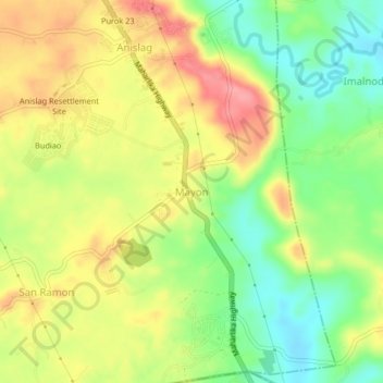
Name: Mayon topographic map, elevation, terrain.

Location: Mayon, Daraga, Albay, Bicol Region, Philippines (13.03936 123.68860 13.07936 123.72860)

Average elevation: 180 ft

Minimum elevation: 26 ft

Maximum elevation: 341 ft

Gear up for your next adventure:

❄️Traction Cleats - Prevent slips on icy trails during winter hikes
📷Action Camera - Capture your outdoor adventures in HD
🦶Hiking Gaiters - Keep debris and water out of your boots
🧺Microfiber Travel Towels - Compact and fast-drying towels for trail use
🛡️Insect Repellent - Protection against bugs during outdoor activities

As an Amazon Associate, this site earns from qualifying purchases at no extra cost to you.