
Make a donation
Gear up for your next adventure:
As an Amazon Associate, this site earns from qualifying purchases at no extra cost to you.
Baccum topographic map
Click on the map to display elevation.
Make a donation
Gear up for your next adventure:
As an Amazon Associate, this site earns from qualifying purchases at no extra cost to you.
Baccum
Die Ortschaft Baccum liegt im Süden des Landkreises Emsland, östlich von Lingen auf einer Höhe von 40 m ü. NN. Der Ort war früher eine Gemeinde und gehört heute zur Stadt Lingen (Ems). Dem ehemaligen Kirchdorf Baccum waren die Gemeinden und Bauerschaften Ramsel und Münnigbüren zugeordnet: Alle drei bildeten zusammen auf einer Grundfläche von 23 km² die Kirchen- und Schulgemeinde Baccum.
Make a donation
Gear up for your next adventure:
As an Amazon Associate, this site earns from qualifying purchases at no extra cost to you.
About this map
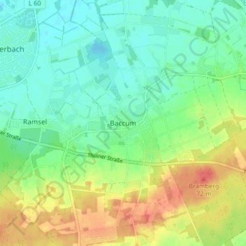
Name: Baccum topographic map, elevation, terrain.
Average elevation: 138 ft
Minimum elevation: 75 ft
Maximum elevation: 236 ft
Make a donation
Gear up for your next adventure:
As an Amazon Associate, this site earns from qualifying purchases at no extra cost to you.
Other topographic maps
Click on a map to view its topography, its elevation and its terrain.
49811
Deutschland > Niedersachsen > Landkreis Emsland > Lingen (Ems) > Baccum > Övernhoff
Average elevation: 108 ft
Make a donation
Gear up for your next adventure:
As an Amazon Associate, this site earns from qualifying purchases at no extra cost to you.