
Huesca topographic map
Click on the map to display elevation.
Huesca
Huesca lies on a plateau in the northern region of Aragón, with an elevation of 488 m (1,601.05 ft) above sea level. Close to the city lie the Sierra de Guara mountains, which reach 2,077 m. The geographical coordinates of the city are: 42° 08´ N, 0° 24´ W.
About this map
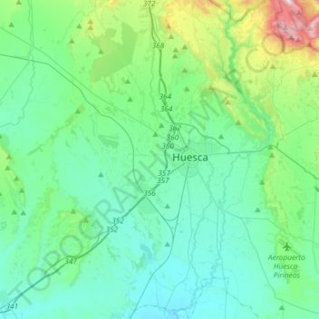
Name: Huesca topographic map, elevation, terrain.
Location: Huesca, Hoya de Huesca / Plana de Uesca, Huesca, Aragon, Spain (42.02802 -0.51791 42.24505 -0.33675)
Average elevation: 1,732 ft
Minimum elevation: 1,204 ft
Maximum elevation: 3,970 ft