
Russell topographic map
Interactive map
Click on the map to display elevation.
Russell
The town has two very different sections: South Quarter is mainly uplands at elevations from 1,000 to 1,400 feet (300 to 430 m) along the rim of a plateau west of the Connecticut River Valley, while the rest of the town is a deep valley along the swift Westfield River.
About this map
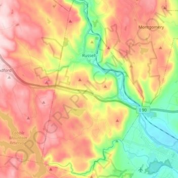
Name: Russell topographic map, elevation, terrain.
Location: Russell, Hampden County, Massachusetts, United States (42.11500 -72.89566 42.22366 -72.81091)
Average elevation: 817 ft
Minimum elevation: 141 ft
Maximum elevation: 1,493 ft
Hampden County trails, hiking, mountain biking, running and outdoor activities
Other topographic maps
Click on a map to view its topography, its elevation and its terrain.
Mittineague
United States > Massachusetts > Hampden County > West Springfield
Average elevation: 161 ft
Palmer Green Estates
United States > Massachusetts > Hampden County > Palmer
Average elevation: 459 ft
Victory Lake Dam
United States > Massachusetts > Hampden County > Camp Spruce Hill
Average elevation: 1,040 ft
Skyland
United States > Massachusetts > Hampden County > Tolland > Skyland
Average elevation: 1,211 ft