
Make a donation
Gear up for your next adventure:
As an Amazon Associate, this site earns from qualifying purchases at no extra cost to you.
Seth topographic map
Click on the map to display elevation.
Make a donation
Gear up for your next adventure:
As an Amazon Associate, this site earns from qualifying purchases at no extra cost to you.
Seth
Das Haufendorf liegt auf einer Terrasse hoch über dem linken Ufer des Vorderrheins. Die Gemeinde reicht von 930 m ü. M. nördlich von Rueun und Schnaus bis auf eine Höhe von 2833 m in der Nähe des Vorab an der Grenze zum Kanton Glarus. Vom gesamten Gemeindegebiet von 1348 ha sind 689 ha landwirtschaftlich nutzbar, darunter sind 565 ha Maiensässen. 453 ha des Gemeindeareals sind von Wald und Gehölz bedeckt und 180 ha unproduktive Fläche (Gebirge). Die restlichen 26 ha sind Siedlungsfläche.
Make a donation
Gear up for your next adventure:
As an Amazon Associate, this site earns from qualifying purchases at no extra cost to you.
About this map
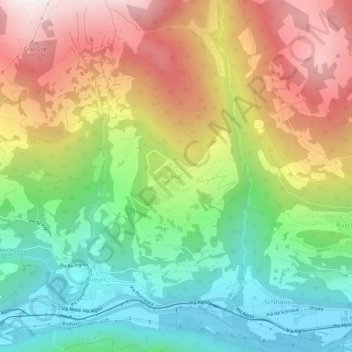
Name: Seth topographic map, elevation, terrain.
Average elevation: 4,183 ft
Minimum elevation: 2,300 ft
Maximum elevation: 6,693 ft
Make a donation
Gear up for your next adventure:
As an Amazon Associate, this site earns from qualifying purchases at no extra cost to you.