
Make a donation
Gear up for your next adventure:
As an Amazon Associate, this site earns from qualifying purchases at no extra cost to you.
Madill topographic map
Click on the map to display elevation.
Make a donation
Gear up for your next adventure:
As an Amazon Associate, this site earns from qualifying purchases at no extra cost to you.
Madill
There is also a small municipal airport (FAA code 1F4) named Madill Municipal Airport, 3 miles (4.8 km) northwest of the city. It has one asphalt runway, 18/36, that is 3,000 feet (910 m) by 60 feet (18 m) at elevation 862 feet (263 m). The airport beacon operates between sunrise and sunset every day. There is no control tower.
Make a donation
Gear up for your next adventure:
As an Amazon Associate, this site earns from qualifying purchases at no extra cost to you.
About this map
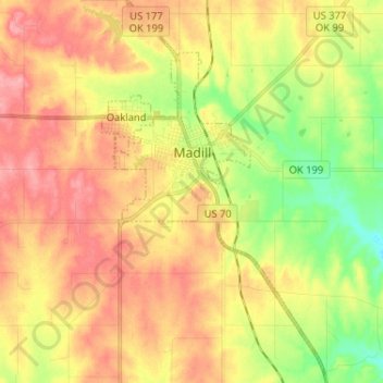
Name: Madill topographic map, elevation, terrain.
Location: Madill, Marshall County, Oklahoma, 73446, United States (34.02561 -96.79837 34.13279 -96.72616)
Average elevation: 814 ft
Minimum elevation: 650 ft
Maximum elevation: 951 ft
Marshall County trails, hiking, mountain biking, running and outdoor activities
Make a donation
Gear up for your next adventure:
As an Amazon Associate, this site earns from qualifying purchases at no extra cost to you.