
Thank you for supporting this site ❤️
Make a donation
Make a donation
Gear up for your next adventure:
As an Amazon Associate, this site earns from qualifying purchases at no extra cost to you.
Weaverham topographic map
Click on the map to display elevation.
Thank you for supporting this site ❤️
Make a donation
Make a donation
Gear up for your next adventure:
As an Amazon Associate, this site earns from qualifying purchases at no extra cost to you.
About this map
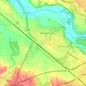
Name: Weaverham topographic map, elevation, terrain.
Location: Weaverham, Cheshire West and Chester, England, United Kingdom (53.24238 -2.60740 53.27363 -2.54262)
Average elevation: 121 ft
Minimum elevation: 20 ft
Maximum elevation: 243 ft
Thank you for supporting this site ❤️
Make a donation
Make a donation
Gear up for your next adventure:
As an Amazon Associate, this site earns from qualifying purchases at no extra cost to you.
Other topographic maps
Click on a map to view its topography, its elevation and its terrain.
Little Stanney Wood
United Kingdom > England > Cheshire West and Chester > Stoak > Little Stanney
Average elevation: 36 ft