
Make a donation
Gear up for your next adventure:
As an Amazon Associate, this site earns from qualifying purchases at no extra cost to you.
Breitenlesau topographic map
Click on the map to display elevation.
Make a donation
Gear up for your next adventure:
As an Amazon Associate, this site earns from qualifying purchases at no extra cost to you.
Breitenlesau
Das Kirchdorf Breitenlesau befindet sich etwa viereinhalb Kilometer nordwestlich von Waischenfeld und liegt auf einer Höhe von 457 Metern.
Make a donation
Gear up for your next adventure:
As an Amazon Associate, this site earns from qualifying purchases at no extra cost to you.
About this map
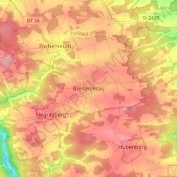
Name: Breitenlesau topographic map, elevation, terrain.
Average elevation: 1,460 ft
Minimum elevation: 1,184 ft
Maximum elevation: 1,585 ft
Make a donation
Gear up for your next adventure:
As an Amazon Associate, this site earns from qualifying purchases at no extra cost to you.
Other topographic maps
Click on a map to view its topography, its elevation and its terrain.
91344
Deutschland > Bayern > Landkreis Bayreuth > Waischenfeld > Heroldsberg
Average elevation: 1,398 ft