Geolocate

Rosetta topographic map

Click on the map to display elevation.

About this map

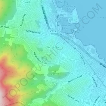
Name: Rosetta topographic map, elevation, terrain.

Location: Rosetta, Hobart, City of Glenorchy, Tasmania, Australia (-42.82754 147.23031 -42.81434 147.26891)

Average elevation: 276 ft

Minimum elevation: -7 ft

Maximum elevation: 1,444 ft

Other topographic maps

Click on a map to view its topography, its elevation and its terrain.

Selfs Point

Australia > Tasmania > Hobart

Average elevation: 56 ft

Waterworks Reserve

Australia > Tasmania > Hobart

Average elevation: 787 ft

James Austin Park

Australia > Tasmania > Hobart

Average elevation: 82 ft

Perrins Ridge

Australia > Tasmania > Hobart

Average elevation: 1,532 ft

Cartwright Point

Australia > Tasmania > Hobart

Average elevation: 194 ft

Mount Direction

Australia > Tasmania > Hobart

Average elevation: 545 ft

Glebe Hill

Australia > Tasmania > Hobart

Average elevation: 217 ft

Knocklofty

Australia > Tasmania > Hobart

Average elevation: 607 ft

Snug Falls

Australia > Tasmania > Hobart > Snug

Average elevation: 1,102 ft

Tolosa Park

Australia > Tasmania > Hobart

Average elevation: 597 ft

Glenrose Park

Australia > Tasmania > Hobart

Average elevation: 594 ft

Gear up for your next adventure:

🪓Survival Multi‑Tool - Versatile tool for camp and trail tasks
🗺️Topographic Maps - Detailed topo maps for hiking, exploring and outdoor navigation
🧺Microfiber Travel Towels - Compact and fast-drying towels for trail use
🧦Merino Wool Socks - Moisture-wicking, blister-preventing socks for long treks
🪶Paracord Bracelet - Survival bracelet with built‑in tools

As an Amazon Associate, this site earns from qualifying purchases at no extra cost to you.