
Make a donation
Gear up for your next adventure:
As an Amazon Associate, this site earns from qualifying purchases at no extra cost to you.
Opglabbekerzavel topographic map
Click on the map to display elevation.
Make a donation
Gear up for your next adventure:
As an Amazon Associate, this site earns from qualifying purchases at no extra cost to you.
About this map
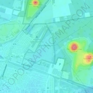
Name: Opglabbekerzavel topographic map, elevation, terrain.
Average elevation: 279 ft
Minimum elevation: 236 ft
Maximum elevation: 538 ft
Make a donation
Gear up for your next adventure:
As an Amazon Associate, this site earns from qualifying purchases at no extra cost to you.
Other topographic maps
Click on a map to view its topography, its elevation and its terrain.
Winterslag
België > Limburg > Hasselt > Genk
Winterslag, gelegen op het Kempens Plateau, werd vrijwel geheel door de steenkoolmijn gevormd. Ook nu is er nog een terril met een hoogte van 163 meter boven de zeespiegel. De mijnterreinen en woonwijken zijn ingebed te midden van autowegen en spoorlijnen, en ook zijn in de omgeving nog enkele bosrestanten te…
Average elevation: 240 ft