
Brown Hill Tract topographic map
Interactive map
Click on the map to display elevation.
About this map
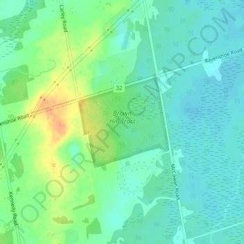
Name: Brown Hill Tract topographic map, elevation, terrain.
Average elevation: 784 ft
Minimum elevation: 741 ft
Maximum elevation: 876 ft
Other topographic maps
Click on a map to view its topography, its elevation and its terrain.
Mount Albert
Canada > Ontario > York Region > East Gwillimbury
Mount Albert, East Gwillimbury, York Region, Golden Horseshoe, Ontario, L0G 1M0, Canada
Average elevation: 856 ft
Sharon
Canada > Ontario > York Region > East Gwillimbury
Sharon, East Gwillimbury, York Region, Golden Horseshoe, Ontario, L9N 0P6, Canada
Average elevation: 879 ft
Brown Hill
Canada > Ontario > York Region > East Gwillimbury
Brown Hill, East Gwillimbury, York Region, Golden Horseshoe, Ontario, L0S 1M0, Canada
Average elevation: 764 ft
East Holland River
Canada > Ontario > York Region > East Gwillimbury > Holland Landing
East Holland River, Holland Landing, East Gwillimbury, York Region, Golden Horseshoe, Ontario, Canada
Average elevation: 732 ft
Holland Landing
Canada > Ontario > York Region > East Gwillimbury
Holland Landing, East Gwillimbury, York Region, Golden Horseshoe, Ontario, L9N 1L8, Canada
Average elevation: 801 ft