
Make a donation
Gear up for your next adventure:
As an Amazon Associate, this site earns from qualifying purchases at no extra cost to you.
Timaná topographic map
Click on the map to display elevation.
Make a donation
Gear up for your next adventure:
As an Amazon Associate, this site earns from qualifying purchases at no extra cost to you.
Timaná
Por la misma topografía, el territorio cuenta con diversas caídas de agua que permiten el disfrute de la naturaleza a los lugareños, proporcionando lugares de sano esparcimiento.
Make a donation
Gear up for your next adventure:
As an Amazon Associate, this site earns from qualifying purchases at no extra cost to you.
About this map
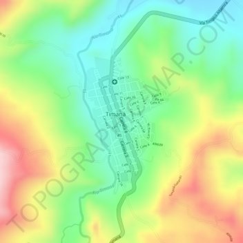
Name: Timaná topographic map, elevation, terrain.
Location: Timaná, Sur, Huila, Colombia (1.96534 -75.93627 1.98163 -75.92673)
Average elevation: 3,504 ft
Minimum elevation: 3,179 ft
Maximum elevation: 3,927 ft
Make a donation
Gear up for your next adventure:
As an Amazon Associate, this site earns from qualifying purchases at no extra cost to you.
Other topographic maps
Click on a map to view its topography, its elevation and its terrain.