Geolocate

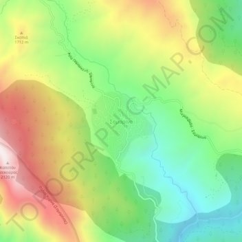
Samarina topographic map

Click on the map to display elevation.

Samarina

Samarina is located on an eastern spur of Mount Smolikas, the highest of the Pindus range and the second-highest mountain in all of Greece. At an altitude of 1380–1515 meters (4528' to 4970'), it is considered one of the highest villages in Greece and also one of the highest in the Balkans; its height puts it among soaring settlements such as: Aetomilitsa (Densko) and Seli (Selia).

Wikipedia (CC-BY-SA 3.0)

About this map

Name: Samarina topographic map, elevation, terrain.

Location: Samarina, Municipality of Grevena, Grevena Regional Unit, Western Macedonia, Epirus and Western Macedonia, 510 32, Greece (40.08443 20.99842 40.12443 21.03842)

Average elevation: 5,112 ft

Minimum elevation: 3,799 ft

Maximum elevation: 6,864 ft

Gear up for your next adventure:

👟Trail Running Shoes - Lightweight shoes for trail runners
🧢Sun Protection Hats - Wide-brimmed and UPF-rated hats for high-altitude sun safety
🦶Carbon Trekking Poles - Reduce knee impact on steep descents with ultra-light poles
🥤Water Filter Bottle - All‑in‑one filter bottle for safe hydration
🛌Ultralight Sleeping Bags - Compact down bags for cold nights in the wilderness

As an Amazon Associate, this site earns from qualifying purchases at no extra cost to you.