Geolocate

Camp topographic map

Click on the map to display elevation.

About this map

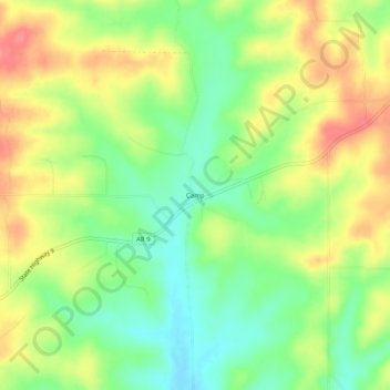
Name: Camp topographic map, elevation, terrain.

Location: Camp, Fulton County, Arkansas, 72520, United States (36.39423 -91.75487 36.43423 -91.71487)

Average elevation: 705 ft

Minimum elevation: 587 ft

Maximum elevation: 837 ft

Fulton County trails, hiking, mountain biking, running and outdoor activities

Gear up for your next adventure:

🎒Hydration Pack - Hands‑free water reservoir for long hikes
🌡️Handheld Weather Meters - Measure wind, temp, and pressure for safe mountain travel
📚USA Hiking Guide Books - Top trail guides and map books
😴Insulated Sleeping Pads - Compact and warm pads for high-elevation camping
🔭Stargazing Telescopes - Perfect for camping in low-light pollution areas shown on maps

As an Amazon Associate, this site earns from qualifying purchases at no extra cost to you.