Geolocate

Talikoti topographic map

Click on the map to display elevation.

Talikoti

Talikoti is located at 16°29′N 76°19′E / 16.48°N 76.32°E / 16.48; 76.32. It has an average elevation of 509 metres (1669 feet).

Wikipedia (CC-BY-SA 3.0)

About this map

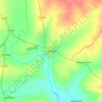
Name: Talikoti topographic map, elevation, terrain.

Location: Talikoti, Talakoti Taluku, Vijayapura district, Karnataka, 586214, India (16.43447 76.27171 16.51447 76.35171)

Average elevation: 1,680 ft

Minimum elevation: 1,591 ft

Maximum elevation: 1,795 ft

Gear up for your next adventure:

🏥Hiking First Aid Kits - Comprehensive medical kits for remote trail injuries
🪶Fire Starter Kit - Reliable fire starter for survival and camping
🎒Outdoor Daypacks - Lightweight backpacks designed for carrying maps and essential gear
🚪Portable Camp Chair - Foldable chair for comfort at camp
🗺️NatGeo Topo Maps - High-quality waterproof printed topographic maps of US Parks

As an Amazon Associate, this site earns from qualifying purchases at no extra cost to you.