
Make a donation
Gear up for your next adventure:
As an Amazon Associate, this site earns from qualifying purchases at no extra cost to you.
Obertilliach topographic map
Click on the map to display elevation.
Make a donation
Gear up for your next adventure:
As an Amazon Associate, this site earns from qualifying purchases at no extra cost to you.
About this map
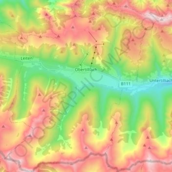
Name: Obertilliach topographic map, elevation, terrain.
Location: Obertilliach, Bezirk Lienz, Tyrol, 9942, Austria (46.65137 12.54971 46.74963 12.67892)
Average elevation: 6,043 ft
Minimum elevation: 3,917 ft
Maximum elevation: 8,458 ft
Make a donation
Gear up for your next adventure:
As an Amazon Associate, this site earns from qualifying purchases at no extra cost to you.
Other topographic maps
Click on a map to view its topography, its elevation and its terrain.
Make a donation
Gear up for your next adventure:
As an Amazon Associate, this site earns from qualifying purchases at no extra cost to you.
Salzbodensee
Austria > Tyrol > Bezirk Lienz > Marktgemeinde Matrei in Osttirol
Average elevation: 7,382 ft
Bobojach
Austria > Tyrol > Bezirk Lienz > Gemeinde Prägraten am Großvenediger
Average elevation: 5,669 ft
Make a donation
Gear up for your next adventure:
As an Amazon Associate, this site earns from qualifying purchases at no extra cost to you.