
Make a donation
Gear up for your next adventure:
As an Amazon Associate, this site earns from qualifying purchases at no extra cost to you.
Wielsbeke topographic map
Click on the map to display elevation.
Make a donation
Gear up for your next adventure:
As an Amazon Associate, this site earns from qualifying purchases at no extra cost to you.
Wielsbeke
Wielsbeke ligt in de vallei van de Leie en deels in het Hoogland van Hulste. De hoogte bedraagt 10-16 meter. De Oude Leie-arm op de grens met Sint-Baafs-Vijve is een restant van de meanderende Leie die in 1974 werd rechtgetrokken.
Make a donation
Gear up for your next adventure:
As an Amazon Associate, this site earns from qualifying purchases at no extra cost to you.
About this map
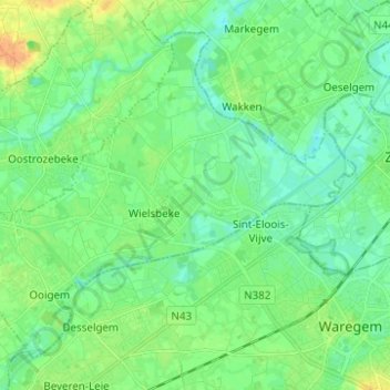
Name: Wielsbeke topographic map, elevation, terrain.
Location: Wielsbeke, Tielt, West-Vlaanderen, Vlaanderen, 8710, België (50.88039 3.31017 50.94570 3.43396)
Average elevation: 46 ft
Minimum elevation: 10 ft
Maximum elevation: 115 ft
Make a donation
Gear up for your next adventure:
As an Amazon Associate, this site earns from qualifying purchases at no extra cost to you.
Other topographic maps
Click on a map to view its topography, its elevation and its terrain.
Make a donation
Gear up for your next adventure:
As an Amazon Associate, this site earns from qualifying purchases at no extra cost to you.