Geolocate

Paddington topographic map

Click on the map to display elevation.

About this map

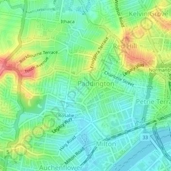
Name: Paddington topographic map, elevation, terrain.

Location: Paddington, Brisbane City, Queensland, 4064, Australia (-27.46863 152.98574 -27.45293 153.01198)

Average elevation: 95 ft

Minimum elevation: 10 ft

Maximum elevation: 256 ft

Other topographic maps

Click on a map to view its topography, its elevation and its terrain.

Willmington Park

Australia > Queensland > Brisbane City

Average elevation: 121 ft

Mount Gravatt

Australia > Queensland > Brisbane City

Average elevation: 230 ft

Ithaca

Australia > Queensland > Brisbane City > Ithaca

Average elevation: 102 ft

Gear up for your next adventure:

🧤Tactile Hiking Gloves - Keep hands warm while operating GPS and smartphone screens
🔌Solar Panel Charger - Charge gear sustainably outdoors
🛠️Backpacking Tool Kit - Essential toolkit for outdoor repairs
🔥Fast-Boil Camping Stoves - Efficient cooking systems for quick trail meals
🦺Reflective Outdoor Gear - Safety gear for low‑light conditions

As an Amazon Associate, this site earns from qualifying purchases at no extra cost to you.