
Make a donation
Gear up for your next adventure:
As an Amazon Associate, this site earns from qualifying purchases at no extra cost to you.
Neunkirchen topographic map
Click on the map to display elevation.
Make a donation
Gear up for your next adventure:
As an Amazon Associate, this site earns from qualifying purchases at no extra cost to you.
About this map
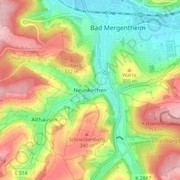
Name: Neunkirchen topographic map, elevation, terrain.
Average elevation: 925 ft
Minimum elevation: 663 ft
Maximum elevation: 1,230 ft
Make a donation
Gear up for your next adventure:
As an Amazon Associate, this site earns from qualifying purchases at no extra cost to you.
Other topographic maps
Click on a map to view its topography, its elevation and its terrain.
Stuppach
Deutschland > Baden-Württemberg > Main-Tauber-Kreis > Bad Mergentheim
Average elevation: 1,106 ft
Neunkirchen
Deutschland > Baden-Württemberg > Main-Tauber-Kreis > Bad Mergentheim
Average elevation: 925 ft
Rengershausen
Deutschland > Baden-Württemberg > Main-Tauber-Kreis > Bad Mergentheim
Average elevation: 1,194 ft
Wachbach
Deutschland > Baden-Württemberg > Main-Tauber-Kreis > Bad Mergentheim
Wachbach liegt etwas über 5 km südsüdöstlich der Stadtmitte von Bad Mergentheim auf Höhen um 252 m ü. NHN im Naturraum der Umpfer-Wachbach-Riedel im bis in den Unteren Muschelkalk eingeteuften Tal des Wachbachs. Zum früher nur den Talgrund, den Hangfuß und den Zulaufbereich des Seitentals Ursprung…
Average elevation: 1,079 ft
Make a donation
Gear up for your next adventure:
As an Amazon Associate, this site earns from qualifying purchases at no extra cost to you.
Herbsthausen
Deutschland > Baden-Württemberg > Main-Tauber-Kreis > Bad Mergentheim
Average elevation: 1,339 ft
Dainbach
Deutschland > Baden-Württemberg > Main-Tauber-Kreis > Bad Mergentheim
Average elevation: 1,093 ft
Tauber
Deutschland > Baden-Württemberg > Main-Tauber-Kreis > Bad Mergentheim > Markelsheim
Average elevation: 879 ft